Archaeological background
Archaeological aerial reconnaissance is a very effective method for site discovery, driven by the specific nature of the archaeological anomalies that remain in the landscape. Aside from up-standing structures, most archaeological remains are partly eroded or only exist as sub-surface archaeological features, showing up on the surface under certain conditions as visibility marks.
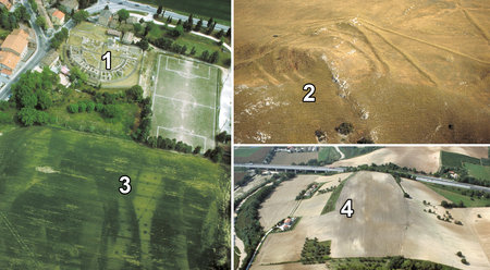
Apart from the less commom flood and wind marks, archaeologists mostly differentiate between four mark types:
- soil marks – varying chemical and physical properties affect the soil colour;
- vegetation marks – due to variable growth and vigour of the vegetation;
- shadow marks – earthworks thrown into relief by low slanting sunlight;
- snow/frost marks – due to differential snow/frost accumulation/melting.
Four different archaeological marks: 1) ruins; 2) shadow marks; 3) vegetation marks; 4) soil marks.
Before these images can be interpreted and their archaeological evidence mapped, they need to be georeferenced. This process assigns spatial information to any kind of spatial data to explicitly define their location and rotation in respect to a specific earth-related coordinate frame.
Although it is sensu stricto not covered by its definition, georeferencing often involves the necessary steps to get rid of the geometric deformations that occur when imaging a 3D scene with a 2D sensor (e.g. topographical relief displacements, tilt displacements and distortion of the optics). Any georeferencing workflow should therefore contain the necessary steps to tackle these factors in order to place each image pixel on its true location on the earth’s surface.
To achieve this, solutions range from very simple planar rectification methods to bundle block approaches that consider all main geometric influencing factors for proper orthorectification. In archaeological terms, the first approach is represented by dedicated low-cost tools such as AERIAL and Airphoto, while more elaborate and expensive photogrammetric software such as the Trimble INPHO Photogrammetric System represent the latter.
Irrespective of the method applied, the image georeferencing is commonly determined with ground control points (GCPs), whose measurement and identification is a pretty time-consuming operation. Especially in large scale archaeological projects with thousands of images, this is currently considered to be the biggest bottleneck.
Next to the specialised software, reference data and photogrammetric experience are required. Therefore, aerial archaeology does often not go beyond the data acquisition stage. As a result, millions of aerial photographs are currently stored in archives. These archives contain an enormous amount of valuable optical information for detecting and documenting archaeological landscapes which cannot be exploited efficiently.
Hence automated techniques for the georeferencing of archaeological aerial photographs are highly desirable. In order to allow an absolute georeferencing, this approach can be based on the available georeferenced reference data (orthophoto and digital terrain model). However, within this workflow several issues of typical archaeological aerial photographs have to be considered:
- both vertical and oblique images are acquired;
- different non-metric (uncalibrated) cameras are used;
- oblique photographs often lack a high number and/or good distribution of possible GCPs;
- oblique aerial photographs are often shot from an extremely oblique viewpoint;
- often even a rough georeferencing is missing [e.g. position information by a hand-held GNSS (global navigation satellite system) receiver].
Automated (ortho)rectification of archaeological aerial photographs
Franz-Klein-Gasse 1
A-1190 Wien
T: +43-1-4277-40486


